
Mosteiro creek
Share Image
-
Mosteiro creek
-
Norte
-
Freixo de Espada à Cinta
-
Douro Internacional Nature Park
Identification and Access
-
No
-
GPS: 41.057778, -6.898333
Base Characterization
-
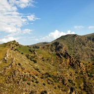
This natural heritage set includes multiple folds in a micro, macro and mesoscopic scale in the quartzites of the Lower Ordvician (about 480 million years ago), outcropping in the valley of the Mosteiro creek. This sequence of rocks formed in shallow seas that limited the continent Gondwana, is crowned by a vertical quartzite strata about 20 m in height, locally known as Muro de Abalona (Abalona Wall Wall).
-
National
Infrastructures
Insituto da Conservação da Natureza e das Florestas, I.P. (ICNF, I.P.)
Mosteiro river – Alpajares causeway trail
North


