
Cycling
Sobreiral (b)


Sobreiral (b)
Share Image
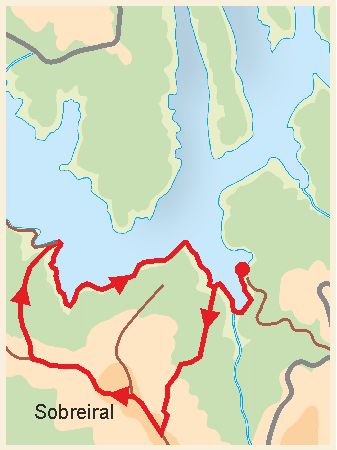
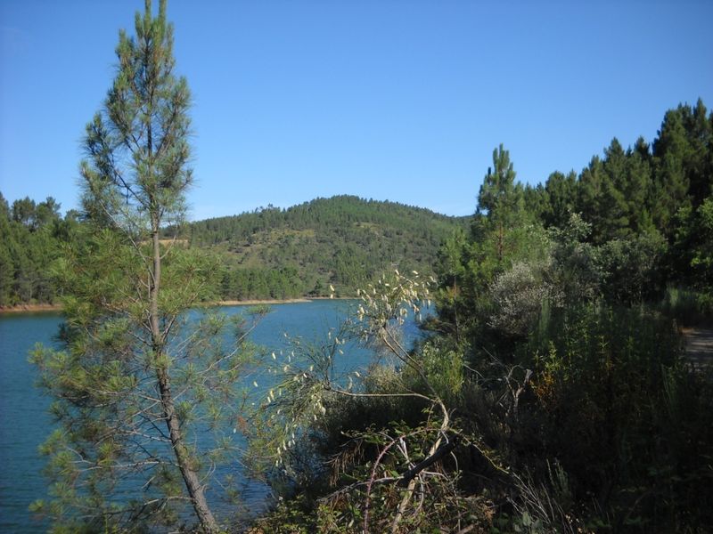
This route is located in the west area of Serra da Malcata Nature Reserve, on one of the slopes of Sobreiral hill that borders Meimoa river dam (built in 1982). The path evolves by Sobreiral hill in areas of Cork Oaks and Strawberry Trees. In Spring a Common Hawthorn area gives a white touch to a small valley that runs through it. Typical of the central region of Malcata mountain, these deciduous woods protects, in its understorey, species such as Paeonia broteri, endemic to the Iberian Peninsula, European Honeysuckle (Lonicera periclymenum), Primula acaulis ssp acaulis (a primrose), Genista falcata (a broom), as well as some orchids. The woods are made up species such as the heath (Erica australis ssp. australis), often used for coal production and as an ornamental, the Poplar-Leaved Cistus (Cistus populifolius), the Montpellier Cistus (Cistus monspeliensis), the Erica umbellata, Rosemary, the Sand-everlasting (Helichrysum stoechas ssp. stoechas), the False Olive (Phillyrea angustifolia) and Foxglove. A substantial part of the trail borders the reservoir and you can observe waterfowl such as the Great Crested Grebe who spends the winter here, the mallard nests in these waters and the gray and white Wagtails run along the banks searching for insects. The Grey Heron and the Black Stork come to the dam to feed at and, though more sporadically, may also be sighted. In winter, this area has the appeal of oak warm colors, while in Summer the visitor can cool off in the bathing area on the other side of the reservoir.

-
This route is located in the west area of Serra da Malcata Nature Reserve, on one of the slopes of Sobreiral hill that borders Meimoa river dam (built in 1982). The path evolves by Sobreiral hill in areas of Cork Oaks and Strawberry Trees. In Spring a Common Hawthorn area gives a white touch to a small valley that runs through it. Typical of the central region of Malcata mountain, these deciduous woods protects, in its understorey, species such as Paeonia broteri, endemic to the Iberian Peninsula, European Honeysuckle (Lonicera periclymenum), Primula acaulis ssp acaulis (a primrose), Genista falcata (a broom), as well as some orchids. The woods are made up species such as the heath (Erica australis ssp. australis), often used for coal production and as an ornamental, the Poplar-Leaved Cistus (Cistus populifolius), the Montpellier Cistus (Cistus monspeliensis), the Erica umbellata, Rosemary, the Sand-everlasting (Helichrysum stoechas ssp. stoechas), the False Olive (Phillyrea angustifolia) and Foxglove. A substantial part of the trail borders the reservoir and you can observe waterfowl such as the Great Crested Grebe who spends the winter here, the mallard nests in these waters and the gray and white Wagtails run along the banks searching for insects. The Grey Heron and the Black Stork come to the dam to feed at and, though more sporadically, may also be sighted. In winter, this area has the appeal of oak warm colors, while in Summer the visitor can cool off in the bathing area on the other side of the reservoir.
-
Center
-
Penamacor
-
Serra da Malcata Nature Reserve
Base Characterization
-
PTCON0004 Malcata
PTZPE0007 Serra da Malcata (Malcata Mountain)
-
Biogenetic Reserve (Council of Europe).
-
ICNF – Instituto da Conservação da Natureza e das Florestas, I.P.
Route Characterization
-
Access coming from:
- North - A25 – N233 (Guarda – Sabugal) – follow to N233 direction Penamacor, turning to Meimão and albufeira da ribeira da Meimoa (ribeira da Meimoa dam); or
- South - A23 – N 233 - exit to Alcains – Penamacor – Meimoa and turn to albufeira (dam).
GPS: 40.255662, -7.116803
-
Yes
-
N332, near Meimoa river dam
-
N332, near Meimoa river dam
-
8.9 kilometers
-
All year long
-
1:30h
-
270 meters (between 551 and 821 meters).
-
Medium
-
Ring road
-
Todos os grupos
Supports in place
-
Signs according to FCMP - Federação de Campismo e Montanhismo de Portugal (Portuguese Camping and Mountaineering Federation) rules. Operational without detail information.
-
Picnic area and river beach.
Topographic Profile
In Meimoa or Meimão, buy what you need (water and food) before the walk.
Access coming from:
- North - A25 – N233 (Guarda – Sabugal) – follow to N233 direction Penamacor, turning to Meimão and albufeira da ribeira da Meimoa (ribeira da Meimoa dam); or
- South - A23 – N 233 - exit to Alcains – Penamacor – Meimoa and turn to albufeira (dam).
GPS: 40.255662, -7.116803


